By Ian Vorster

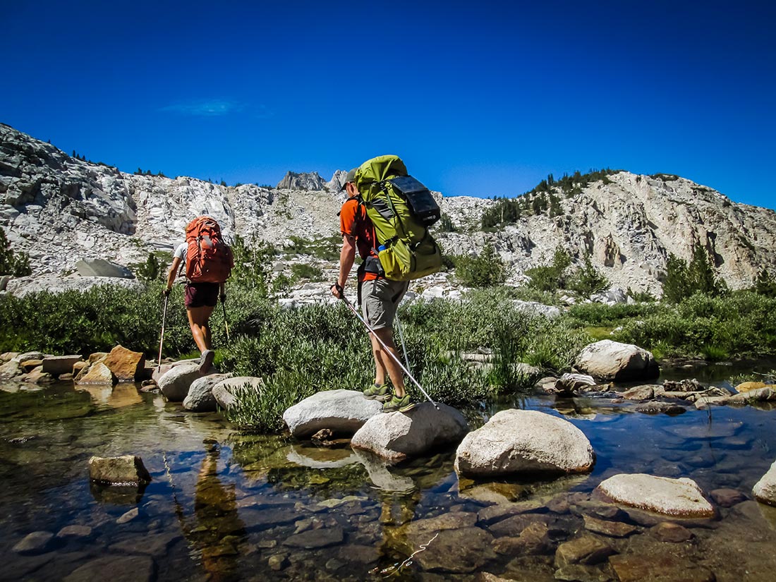
A LITTLE POCKET MEADOW AT the apex of the Golden Staircase climb catches my attention as I labor through what is known among backpackers as timberline, on the John Muir Trail. Roughly a good fly cast wide, a number of small waterfalls tumble through it, each creating their own diminutive ecosystem, and all linked by the hurrying Palisade Creek. The meadow, speckled with a few hardy whitebark pines, looks like something a team of landscape engineers at Disneyland might like to emulate — sculpted by seasons and weather, it leaves one with the sense that this was precisely where Muir’s Creator stood and said, “It is good.”
Needing time to reflect, I shed my pack, shoes and socks, and placed my feet in an icy eddy of the creek. Nearby, a trout hovered delicately in the riffles. Little more than a pine needle long, no sign of anxiety appeared to unsettle him. This was a prime lie — the term used to describe the nexus of food, oxygen and temperature for a trout. A moment later, he exploded from the water to snatch a bug, splashing back into the creek to vanish from sight.

This picture seems to describe just how human-caused climate change is working at this altitude — lying in wait to ambuscade nature.
Adelaide Johnson, a hydrologist with the U.S. Forest Service’s Pacific Northwest Research Station, defines timberline as forestline — considered to be the upper limit of trees of large stature. The location from forestline to treeline, the upper limit of trees where growth is often stunted, is known as the alpine treeline ecotone.
“Change is occurring in many, but not all alpine treeline ecotone locations because of climate change,” she says.
Johnson has observed that, in some areas, the alpine treeline ecotone is moving up in elevation. Factors, such as shade and moisture level and temperature level substrate, are playing a role on the survival of seedlings and likelihood of upward forest migration.
SHIFTING ELEVATIONS
The John Muir Trail (JMT) isn’t some grand six-month trek up K2, but for the average person it’s a pretty big deal. With around 50,000 feet of elevation gain, every hiker wakes up in the morning and thinks about the climbs they have ahead of them. There is some delightfully level trail on the hike, but there is also precious little of it.
Muir didn’t walk the route in the same linear fashion modern day backpackers do, and he certainly didn’t enjoy use of all the new-fangled ultralight gear. But, he did roam these mountains and their forests with a knapsack and stale loaf of bread at the beginning of the industrial period, a time when climate change was starting to gain measurable momentum. His exploration was epitomized with this quote: “When we try to pick out anything by itself we find that it is bound fast by a thousand invisible cords that cannot be broken, to everything in the universe.”

“Hiking the JMT now, one cool thing is that you would have the chance to see all of the species that John Muir would have seen,” Beissigner says. “Our resurveys of sites visited by Professor Grinnell and his students have documented that all of the species they detected in the 1920s can still be found in the national parks — Kings Canyon, Sequoia and Yosemite. So, the parks are doing their job!”
However, it is much harder to see them, as many species are responding to the changing climate by shifting their elevational ranges. Some of the small mammals and birds have moved further upslope as the climate has warmed. The alpine chipmunk, Belding’s ground squirrel, water shrew and pika are high-elevation species of small mammals that have all retreated upslope. Birds also show some species, such as the savannah sparrow, black phoebe and white-breasted nuthatch, shifting up.
“These are patterns we would expect with climate warming, but the picture is a bit more complicated because some species of birds and mammals shifted their elevational ranges downslope,” Beissinger says. “And, it was unpredictable which species responded by moving up or down. Even closely related species in the same area were shifting differently. I am hopeful that many will have the flexibility to respond. The question is whether they can respond fast enough to keep up with a rapidly changing climate.”

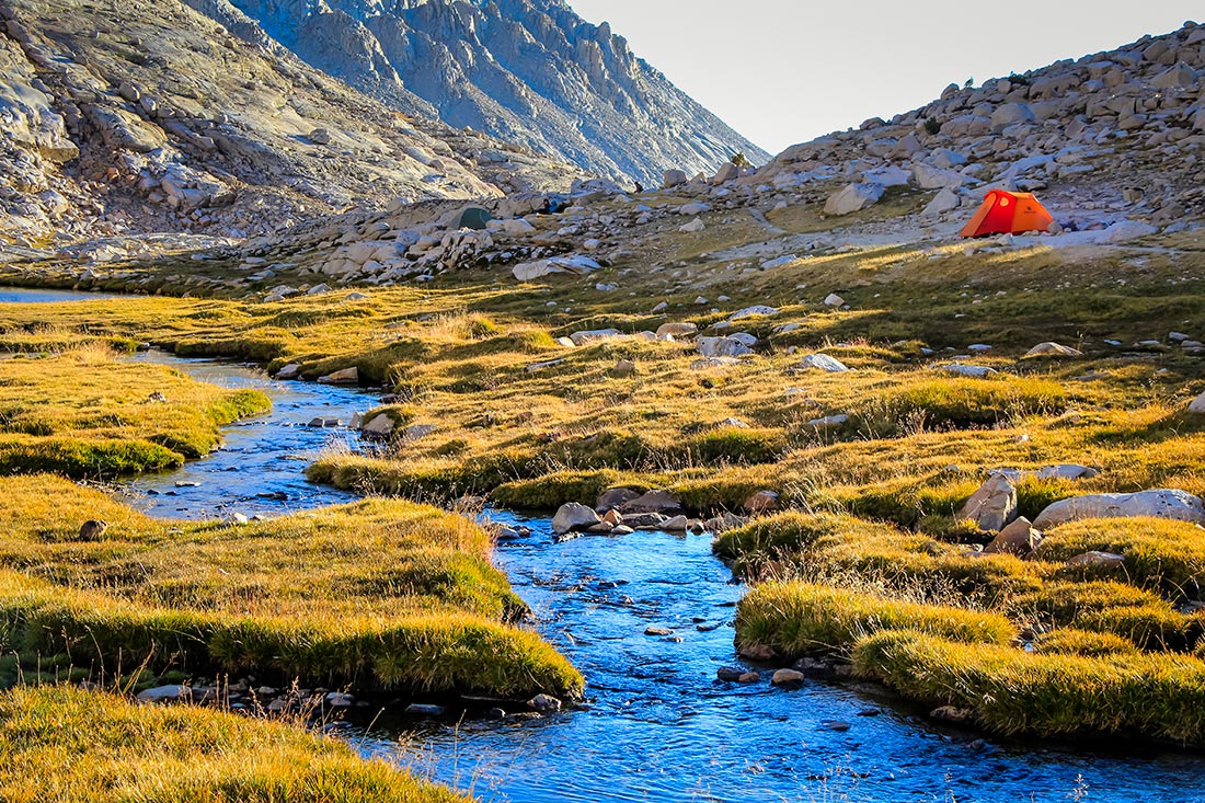
feet above sea level and what is traditionally known as timberline by backpackers — sparsely forested, granite outcrops and garden-like settings. Credit: Ian Vorster.
CHANGING LANDSCAPES
Kings Canyon National Park! I had just crossed a footbridge over Piute Creek where it joins the San Joaquin River and saw a little sign that announced the boundary of the park. Yosemite National Park, Ansel Adams Wilderness and John Muir Wilderness — I had walked with a pack through these great places, and I was determined to add Kings Canyon to the list.
I made 17 miles by 2:30 p.m., passing a number of bristlecone and whitebark pine trees along the way. Bristlecone pines are the oldest known living things on earth. Some date to 4,600 years old, and many of these grow along portions of the JMT. It’s a special species, growing only between 7,500 and 11,500 feet above sea level. The severity of the environment actually seems to be the secret to their longevity. High winds, short growing seasons and bitter cold would describe the perfect climate for a bristlecone.
The whitebark pine is no less gracious — in healthy form. But, populations of these trees are suffering from white pine blister rust and the invasive mountain pine beetle — able to thrive at that altitude because of climate change. In 2011, the National Park Service determined that the species warrants protection under the Endangered Species Act due to the fact that it faces an “imminent” risk of extinction.
As I approached the limit of timberline, I sat down with my back against a rock at the base of Muir Pass. Looking up, I saw a guy hiking up the trail with what looked like a daypack.
“What does your pack weigh?” I asked.
With a grin he called back, “With a week’s food, it weighs 16 pounds.”
“That’s insane!” I exclaimed. “Mine weighs 23 pounds, how do you do it?”
“Well, I followed the standard list of bare essentials, and I eat a lot of granola bars. I’ve also made my own 20-degree quilt,” he replied, which told me he had been frequenting the same online ultralight forums as I had. A quilt means you don’t have to sew in a zipper, which means you don’t have to carry the zipper, helping to get your pack weight down!
Steve was a soil scientist from Ohio who was averaging 25 miles a day. I followed him over Muir Pass, although he quickly left me far behind. I made Muir Hut at the top of the pass at 4 p.m., spent 15 minutes at the hut, took a quick look inside and then began a slow and careful descent.
The mountains were covered in low, cold thunderclouds as I walked away from the pass. Each hiker struggles on a different pass at a different time, depending on how they feel. I was now struggling with the southern descent down the 13,000- foot pass. It was a typical alpine way — something you would imagine seeing in the Himalayas. Thousands of gigantic boulders were strewn along the trail, thrown off nearby cliffs by forces of heat, cold, snow and rain. I walked very carefully, aiming for timberline far below.
At 7 p.m. I passed two tents in a glade on the right side of the trail. I would have kept on walking because the spot was full, but just then heard a voice call out from the left, “Ian, is that you?” It was Steve. Together, we enjoyed a thoroughly good ‘ultralight’ evening.

PEAKS & PASSES
Over our dinner, Steve made an interesting observation.
“It’s weird that they named each of the peaks and passes after characters that were pretty much arch enemies,” Steve said. “Muir was a protectionist, while Pinchot was the first great gooduse guy. And, Whitney was a formal geologist who had some dislike for Muir, who, as an amateur, wrote and was published about his geological theory on the origins of Yosemite.”
Muir captured the imagination of readers with his ecological-theological language. By age 11, he could quote all of the New Testament and most of the Old Testament of the Bible. Using the language of scripture, he explained the natural processes of creation. Whitney tried to discredit Muir by branding him as an amateur. They weren’t friendly.
Thinking about the many peaks along the JMT, I consider other elements shifting in the wake of
climate change. Glaciers — something the average hiker might notice — are retreating rapidly with the warming climate. Susan Kocher, a forestry and natural resources advisor and a registered professional forester with the University of California Cooperative Extension, Central Sierra, and Kim Ingram, a University of California Cooperative Extension Natural Resources Community Education Specialist, say in an article published in California Naturalist that, “Temperatures are increasing, though whether precipitation will increase or decrease in the long run is not yet known. An additional temperature increase of just a few degrees is enough to turn snow into rain throughout the rain–snow transition zone. Depending on the model used, the spring Sierra Nevada snowpack could be reduced by as much as 70 to 90 percent by the end of the century.”

When I reached Bubbs Creek, my third-to-last night on the trail, I enjoyed a signature trailside evening. I had walked out over Kearsarge Pass to resupply and hiked back in over the same pass to make a delightful campsite just beyond Vidette Meadow. Big thunderheads were brewing, and it began to rain intermittently. As the day came to an end, I looked up and realized that the sun might break through the clouds to paint the entire landscape with alpenglow. I grabbed my camera and walked down to the creek.
There, I noticed a couple of fly fishermen casting for their supper. Wearing plaid shirts and heavy-duty shorts, these guys seemed to be outdoorsman in the mold of Huck Fin and Tom Sawyer. As they worked the water, I noted that they were fishing as best they could. They were doing everything right — keeping low, standing back from the bank, using shrub cover and moving with caution.
Two days later, Guitar Lake campsite, the last place to hunker down for a night, was filling up quickly. Small parties were filing over the nearby ridge, some would dump their packs and walk around, flicking aside rocks with a boot before deciding where to pitch their tent.
Looming above Guitar Lake stands Mt. Whitney. I stirred at 4 a.m. on the last day, stuck my head out the tent door and gazed at a stunning star-filled heaven. The outline of the mountain was etched like a petroglyph against the eastern sky.
I had to make about 3,500 feet over four miles to gain the summit. I dropped my pack at the Trail Crest junction and fueled up with water and a couple energy bars, before setting out on the last two miles.
The summit experience was everything I had hoped for. Looking out across the Sierra Nevada mountains, my thoughts turned to some of the characters, both young and old, I had met along the trail. As we had walked together for a day or two, each had shared their motivation for hiking the John Muir Trail with me. And, winding like a track through it all were these two things: the superlative backdrop at timberline, and the fact that some had wanted to walk it for the last 30 or 40 years, or had walked it so many years ago and were now repeating the exercise.
Perhaps that is what is so special about the trail, and about the foresight of people like Muir. We have to leave these treasured landscapes for the generations that follow. Muir had no idea about climate change, and I wonder sometimes about the language he might use to describe his observations about it. At least, for now, despite the changing climate, we can still travel along the same path and see the same sites. We may just have to work a little harder for them.
A native South African, Ian is an award-winning photographer, designer and writer, who is passionate about environmental communications and the world of outdoor adventure. See more at: www.ianvorsterphotography.com.